| อุทยานแห่งชาติหมู่เกาะเภตรา Mu Ko Phetra National Park |
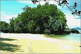
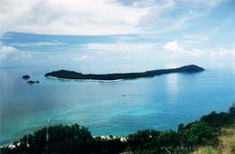
| อุทยานแห่งชาติหมู่เกาะเภตรา ส่วนใหญ่เป็นเกาะเขาหินปูนที่มีความลาดชันสูง มีที่ราบเพียงเล็กน้อยในบริเวณที่เป็นหุบเขาและชายหาด ประกอบด้วยเกาะมากกว่า 22 เกาะ กลางท้องทะเลอันดามัน ที่เรียงรายกระจัดกระจายตั้งแต่เขตอำเภอละงู อำเภอทุ่งหว้า จังหวัดสตูล เรื่อยไปจนจรดอำเภอปะเหลียน จังหวัดตรัง ครอบคลุมพื้นที่ชายฝั่งทะเลและเกาะน้อยใหญ่ โดยมีเกาะที่สำคัญเรียงจากเหนือไปใต้คือ เกาะเหลาเหลียงเหนือ เกาะเหลาเหลียงใต้ เกาะเบ็ง เกาะตากใบ เกาะกล้วย เกาะตุงกู เกาะละมะ เกาะบุโหลนขี้นก เกาะบุโหลนใหญ่ เกาะบุโหลนไม้ไผ่ เกาะเขาใหญ่ และเกาะลิดี The park is situated on the Andaman sea coast in Satun and Trang provinces. It consists of an area of coastline and over 30 islands. The park has many diverse habitats including; open water, coral fringed islands, sandy beaches, forest covered islands to sheer rocky islands which rise steeply out of the sea. There are also a few patches of mangrove forest, beach forest and tropical forest. The islands within the park are small the largest being Khao Yai Island which is about 4.7 sq.km in area. The sea area of the park includes many important fishing grounds for this reason many of the islands act as temporary refuges for fishing boats during monsoon storms. |
  |
|
อุทยานแห่งชาติตะรุเตา Ta Ru Tao National Park |
  |
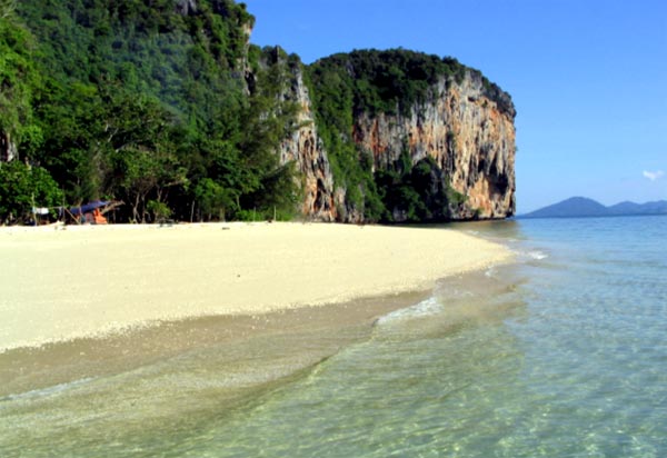
เกาะตะรุเตา มีสภาพพื้นที่ส่วนใหญ่เป็นภูเขามีความลาดชันสูง ชายฝั่งทางด้านตะวันออก ส่วนมากจะเป็นหน้าผาสูงชันสลับกับอ่าวและหาดทรายโคลน ทางด้านตะวันตกจะมีหน้าผาเฉพาะทางด้านเหนือบริเวณแหลมตันหยงมะระ(ด้านหัวเกาะ) มีที่ราบอยู่เป็นหย่อมๆ ทางเทือกเขาหลังอ่าว อ่าวที่สำคัญได้แก่ อ่าวพันเตมะละกา อ่าวสน อ่าวมะขาม อ่าวตะโละอุดัง และอ่าวตะโละวาว เป็นต้น อ่าวต่างๆ เหล่านี้มีคลองและลำธารไหลผ่านออกสู่ทะเล มีที่ราบเล็กน้อย เกาะอาดัง-ราวี อยู่ห่างจากเกาะตะรุเตาไปทางทิศตะวันตกประมาณ 40 กิโลเมตร สภาพพื้นที่เป็นเทือกเขาสูงครอบคลุมเนื้อที่เกือบทั้งหมดของเกาะ มีที่ราบเฉพาะบริเวณเหนือชายหาดต่างๆี Tarutao is a Malay work meaning old, mysterious and primitive. Preliminary geological work has borne out the first of these adjectives. Much of Tarutao is composed of very old Cambrian sandstone. The northern and southeastern portions of the island consist of limestone rock. Most of the caves on the island are formed in limestone rock. |
|
เกาะหลีเป๊ะ Koh Lipe |
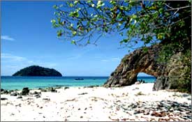
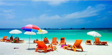
เกาะหลีเป๊ะ อุดมไปด้วย ท้องทะเลที่ใสสะอาด เกาะที่เงียบสงบ และน้ำที่ตื้นเขิน โดย เกาะหลีเป๊ะ มีหาดที่สำคัญๆ อยู่ 4 หาดคือ หาดพัทยา อยู่ทางตอนใต้ ซึ่งเป็นเกาะที่นักท่องเที่ยวนิยมเดินทางไปมาก หาดซันไรท์ อยู่ทางทิศตะวันออก ใกล้ๆ กับหมู่บ้านชาวเล หาดคาร์มา อยู่ทางตอนเหนือ ซึ่งหันหน้าเข้าเกาะอาดัง หาดซันเซ็ท อยู่ทางทิศตะวันตก หันหน้าเข้ารับแสงอาทิตย์ ตามชื่อของหาดี |
  |
|
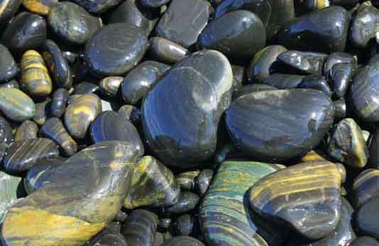
เกาะหินงาม Koh Hin Ngam |
ตั้งอยู่ในเขต อุทยานแห่งชาติตะรุเตา เป็นเกาะเล็กๆ ที่เป็นหาดหิน เต็มไปด้วยก้อนหินสีดำ กลมเกลี้ยง เนื่องจากถูกขัดสีด้วยแรงคลื่น ดูงามสดสวย เมื่อถูกน้ำประกายวาววับ หินทุกก้อนที่หาดแห่งนี้มีคำสาปเจ้าพ่อตะรุเตา ห้ามนำ เคลื่อนย้ายออกจากเขตอุทยานแห่งชาติ
|
  |